I’m a very amateur geology enthusiast - I love thinking and writing about it, but there are bound to be inaccuracies. To me that doesn’t matter so much. I love trying to figure out the story in deep time which led to the beauty in color, form and texture that we see today. So I’m writing this for my own pleasure. Come along if you like!
I'm writing here to think through the formation of the anticline from the last post. (editor's note: This got way too complex. I won't do this again!) It's made out of many layers of sedimentation accumulated over eons. Picture a multi-colored layer cake. Tectonic compression pushed the flat layers up, like a foot pushing a rug up into a fold. It makes sense that the top of the fold would crack, allowing rain and ice to begin hollowing out the center into the valley we see today. That created a 'breached anticline' or ' anticlinal valley.' This photo shows one side of that valley.

The bottom layer was laid down in the Late Triassic - 205-210 millions years ago (that's 210,000,000!), when this area was the floodplain of a large river system (flat!) with small dinosaurs roaming and little mammals getting a start. The silts and muds, containing the iron that later oxidized into red (rusted!), were eventually covered with so much more earth that the weight compressed and heated them into siltstone and mudstone (fairly easy to erode when exposed later on).
This covering was aeolian, meaning sand dunes accumulated. (These became the Entrada Sandstone that Georgia O’Keeffe loved to paint around Ghost Ranch -- a gorgeous area I'll describe in a later post.) This happened 180-140 MYA, during the Middle Jurassic, when the bigger dinosaurs were wandering over the sand.
Then the Jurassic Ocean moved northward with shallow extensions covering parts of New Mexico.

As it retreated it left land-locked water — a lake that slowly evaporated. Early on, marine organisms left their tiny shells to add a layer of limestone. As the lake continued to evaporate and its salts became more concentrated, they precipitated out, eventually hardening as a layer of gypsum. White Mesa (former post and below - the thin white against the distant mountains) was the result.
In a side note, those far mountains, the Sierra Nacimiento, are like bookends with the Sangre de Cristo Mountains above Santa Fe, forming the boundaries of the Rio Grande Rift Valley.
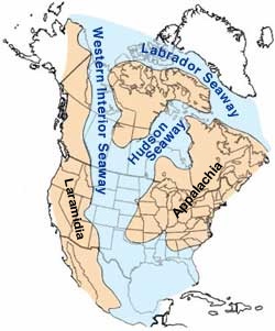
Back to the anticline: In the late Cretaceous (@93-125 MYA) The Western Interior Seaway had moved in (below). Apparently the downwarping that allowed this began with the Laramide Orogeny, when the tectonic plates beneath the Pacific pushed against then slid under the US continental plate. This created compression in the interior, beginning to push up the modern Rockies (there were ancient Rockies, but they'd eroded away long before!). As they pushed up, the earth eastward warped downward, allowing the sea to flow in. Many sorts of deposits are associated with this inland sea, resulting in a variety of types of deposits creating beautiful layers of gold, black, and orange-yellow shales, sand-, silt-, and mudstones.

Later on, mineral springs deposited the whitish travertine that would be the capstone (or frosting on the cake) of the layers or beds built up over millions of years. So picture this: Over vast periods of time, each layer of sedimentation is buried deeper and deeper by later accumulations. The weight creates pressure and intense heat that cooks this layer cake of muds and sands into something that will hold together -- sedimentary stone. (If it had been cooked longer and hotter, we'd have had metamorphic rocks like marble from limestone, slate from shale, and quartzite from sandstone).
This is all flat, but continuing compression buckled the area upward and our cake became a hill. So the whitish travertine we see atop each ridge was originally connected across the entire hill, with all those various layers beneath. But travertine is naturally holy and the rains and ice that crept in gradually eroded out the center, leaving us with the anticlinal valley and all its fascinating beauty.